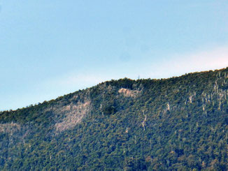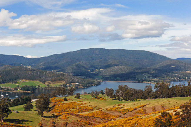
I'm house-sitting in Cygnet, Tasmania, again. This time I'm on the hills looking across Port Cygnet and the inlet. The dominant feature of my view is Mount Cygnet, the summit of a long mountain ridge. You can see Mount Cygnet from all around this area, so, by implication, the view from the top should be extensive. I’ve been eying Mount Cygnet off as a bushwalking destination for a while during my various house-sits here in Cygnet, and I’ve recently worked out how to do it!
Here's the view from my current house-sit, with Mount Cygnet on the horizon:
There are lots of forested Hills around Cygnet and throughout the Huon Valley, and I've wanted to bushwalk on many of them. However, there is no access to most of them, due to the surrounding private property. Mount Cygnet itself is a publicly-accessible forestry reserve, so I just had to find a way past the private properties that surround it to get to its summit.
Planning the bushwalk
I have seen forestry access tracks on maps and on Google Earth, and I have seen a way through the private property on these tracks to get access to the summit of Mount Cygnet. I've checked these out on Google Earth and I can see them there too, so they look likely to be real.
I've also heard that the summit is heavily forested, and that there's nowhere you can get a good view. However with Mount Cygnet filling the view from my house-sit, I've had plenty of opportunity to look at it carefully, and I can see a few bare rocky patches near the summit from which there should be a good view.
My Tasmanian-bushwalking mate Denis (from Hiking South East Tasmania blog) and I decided to do the walk to find out.
Our ascent
The Forestry access track starts from a quiet country road near Cygnet. We parked the car and started walking up the track, at first the track was very good, virtually a road, like this:
After a few kilometres it became boggy but still easily traversable, like this:
However, we eventually needed to turn onto a very old track. I don't think this track has been used for several decades; consequently it’s extremely overgrown, with many fallen trees to climb over and under. We could tell that we were on the track because we could see the cuttings and embankments through the shrubbery, but it was extremely overgrown, like this:
Here’s Denis ahead of me, pushing through the shrubbery:
The bush was so thick, that the last half-a-kilometre before we reached the top took us an hour-and-a-quarter! We were pushing through head-high cutting grass, climbing over and crawling under huge fallen trees, and were continually changing direction to find a way through.
Cutting Grass (gahnia grandis) is no fun to walk through – it has long strap-like leaves with microscopic teeth on one surface. The leaves are extremely strong and flexible; they wrap around your arms and around your neck and the teeth grip you as you push through, so that you end up with cuts and scratches over any bare skin.
The whole of this climb is on the south-east side of the mountain, and anything on the south side of a mountain in Tasmania doesn't get much sun, so it’s usually damp – there was moss, mud, and wetness everywhere, including on us.
On the summit
When we finally did get to the top the view was every bit as good as we had hoped it would be. Here's a panorama of the best part of the view:
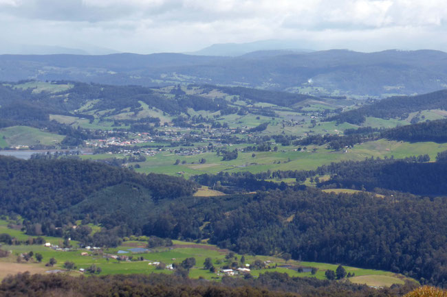
Here are some closer views; this is Cygnet Township in its little valley:
This is the district of Lymington, downstream from Cygnet:
Here's me, sitting back on the Rocks enjoying the view:
Note the state of my jeans from pushing through the bush and climbing over the fallen trees!
Wildlife
Pretty much anywhere on Earth that you’re in close contact with permanently wet bush, you’re going to find leeches. I didn't know it then, but, while I was sitting there enjoying the view, I had four or five of them under those jeans and inside my boots. When I got home I took my boots off and made a bloody mess of the floor before I realised they had been there! Denis tells me he had seven.
I found this brightly coloured red and black spider on a tree near the summit. I looked it up, and, prosaically, it's called a red and black spider. It's only a small one, about 15 millimetres long, and, despite the striking appearance, it’s bite isn’t dangerous.
Our descent
We were aware of a much more direct track to the top of the mountain, but we hadn't been able to confirm that it wasn't on private property, so we didn’t use it to climb the mountain. After our difficult ascent we decided to chance it, and use this track to get down. As it happens, there was no sign that it was on private property, and it probably just goes through another forestry reserve. Getting up had taken us about three hours, and getting back down took us just fifty minutes!
The walk
The walk up and down the mountain wasn’t very picturesque – mostly degraded regrowth bush, but the view from the top was excellent.
This walk was challenging, but also satisfying: there’s nothing like going through untracked heavy bush at less than half-a-kilometre-per-hour, slipping, sliding, falling, and getting scratched up by the vegetation, with limited inputs for navigation (except GPS, which is, admittedly, a huge input for navigation), to make you feel like you’re doing REAL bushwalking – none of that namby-pamby, signposted, graded walking-tracks stuff! Of course, if I go back up Mount Cygnet again, I'll be going up and down the way I came down this time!
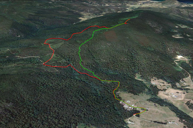
Our walk to the top of Mount Cygnet was 8.1 kilometres return from where we parked the car; five kilometres out, and 3.1 kilometres back. The whole walk, including fighting through the bush, and stopping for lunch and the view, took four-and-a-half hours. The summit of Mount Cygnet is 595 metres high. We climbed a total of 472 metres. Here’s a Google Earth aerial view of our route:
The red track is our route out, and the green track is our route back.
If you want to do this walk I would suggest using our return route both ways, even though it’s just walking along a rough dirt road. I wasn’t able to confirm absolutely that our return route isn’t on private property, although that seems unlikely. If you want to do this walk, you can download my KML file for your GPS app. or GPS unit here, to help you to find your way.
We parked the car on the side of Blue Gum Road, here (on Google Maps).
Tags
If you enjoyed this blog post, you can find related posts under these headings:
Australia, Tasmania, Bushwalking, House-sitting, Kayaking, Practical.
Share this The Journey and the Destination post using your favourite social media:
Would you like to add something, or ask a question? Add a comment below (you can leave the 'Website' field blank):


Chris (The Journey and the Destination) (Sunday, 06 October 2024 13:54)
Good idea, Jane!
Jane Ambrose (Saturday, 01 June 2024 00:15)
I live in Cygnet and have never thought about climbing Mount Cygnet. Thankyou for your description of your climb. I won’t do it! lol I’m off to Burtons Reserve:-)
Chris (The Journey and the Destination) (Friday, 27 October 2017 23:45)
Thanks Judi; if the first photo of the view from the summit was clearer, you'd be able to see your house on it!
Judi (Friday, 27 October 2017 22:17)
Very impressed with your fortitude and tenacity Chris! You have opened our eyes to the reality of part of our every day view. Great story.