
Mount Barrow is one of three large mountains east of Launceston, which can be seen from all over the city. (The others are Mount Arthur and Ben Lomond.)
Mount Barrow is an alpine plateau about 4 kilometres long, with two main summits: Mount Barrow itself, and South Barrow.
I’ve recently climbed Mount Barrow, and explored its alpine plateau.
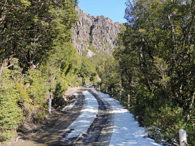
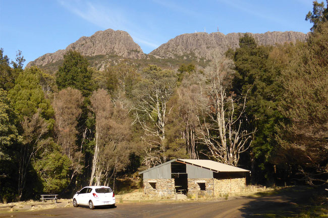
My original intention was to drive to the plateau of Mount Barrow and explore from there; but, as I wasn’t sure about the road conditions at the top, I changed my mind and parked at the bottom of the mountain and walked up on the road, which worked out fine.
Views from the top
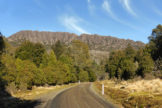
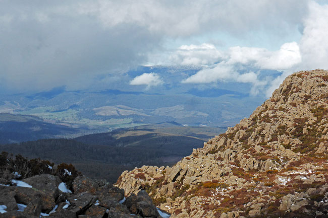
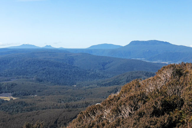
As I expected, the views from the mountain over the surrounding countryside were excellent. This is the view from near the top of the road looking along the summit ridge, towards Mount Arthur, which I’ve climbed previously, in the distance:
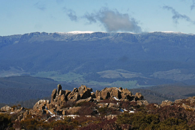
From the plateau I could see nearby Ben Lomond, which I’ve also visited previously, and its snowy cap.
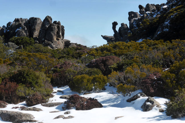
Crossing the alpine plateau
I didn't climb right up to the summit of Mount Barrow, which is 1414 metres, because I was more interested in crossing the alpine plateau to South Barrow, the peak at the other end, which is about 1380 metres.
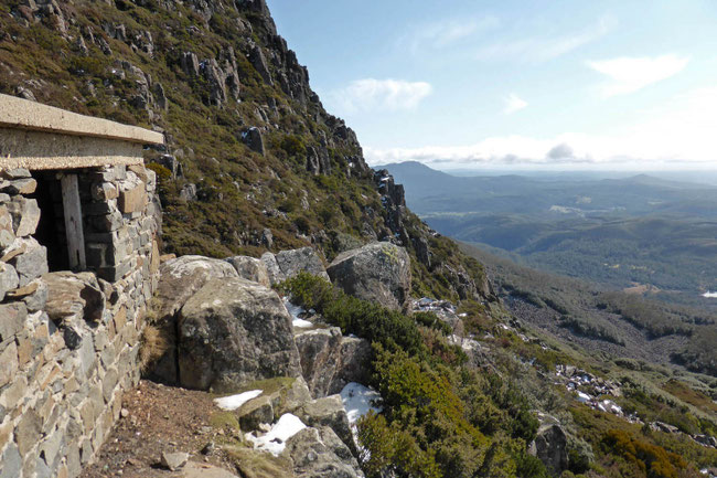
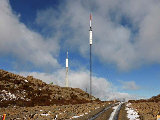
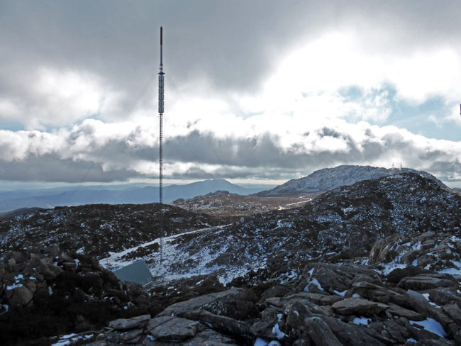
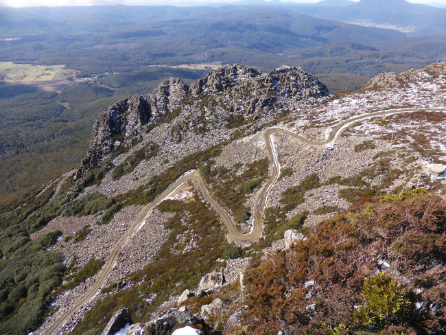
There are communication towers at both summits, so the road continues across the alpine plateau for access to the communications towers at South Barrow. This is the view from near the summit of Mount Barrow, looking across the plateau to the communication towers on South Barrow:
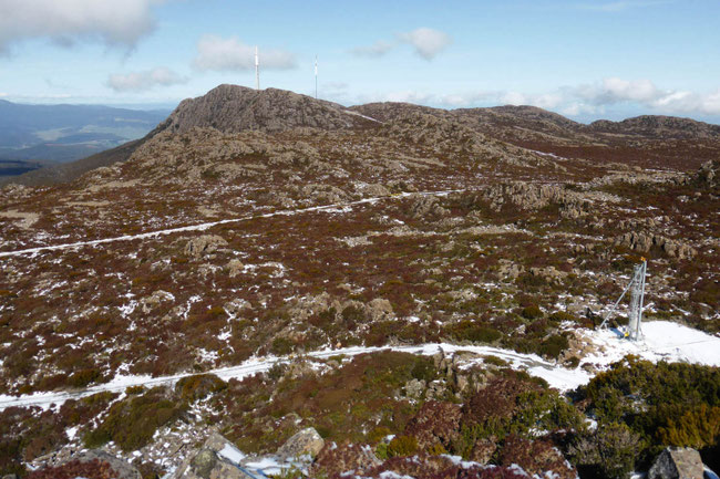
The white line across the plateau is snow on the road that crosses it.
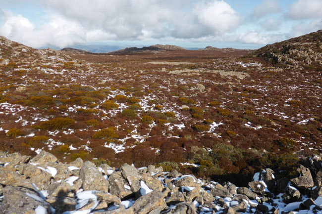
The plateau is covered in the usual alpine heath vegetation, and there are some interesting rock formations.
Here are the communications towers on South Barrow, as I approached them:
The structures on the tops of the towers were packed with ice left over from the winter. As the weather was warming, 2-or-3 kilogram chunks of ice were continually plummeting 50 metres from the tops of the towers and crashing on to the surrounding ground.
This is the view from near the base of one of the towers on South Barrow (not too near, because of the falling ice), looking back to the summit of Mount Barrow at the other end of the plateau, with Mount Arthur in the distance:
You can see the white line of the road disappearing into the distance across the plateau.
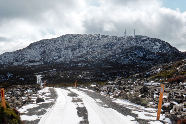
Here's another view of the Mount Barrow and the road across the plateau:
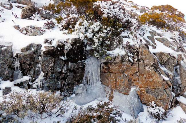
As always, being from the subtropics, the snow and ice intrigues me; here's a small frozen waterfall near the towers:
By the time I had walked the couple of kilometres along the road on the plateau some cloud had built up, making a picturesque view of nearby Ben Lomond.
The plateau continues beyond the end of the road, but there are no tracks on it.
I tried walking out a little way on to it, but despite its open appearance, it's very hard going on the rough scree surface.
Planning the walk
When I initially considered walking on Mount Barrow, my intention was to drive straight to the top and explore the Mountain’s large alpine plateau.
I looked on maps for walking tracks on the plateau; but, to my surprise, I found that there aren’t any. This may be due to the extremely rugged scree-field terrain.
As well as the lack of walking tracks on the plateau there is also the issue that it’s late winter, and there’s still plenty of snow around, so I wasn’t sure that conditions on the road to the top would be suitable for the small two-wheel-drive car that I’m driving.
The lack of walking tracks and the possible poor road conditions led me to change my plans from driving to the top, to instead parking at the bottom of the mountain and walking up to the plateau on the road. I was a little disappointed to come to this conclusion, as I was looking forward to something more interesting than simply walking on a road. However, I decided to treat the road as a very wide, consistently sloped, and easy, walking track. This turned out to be a good decision – the road did indeed have snow on it, and there were limited opportunities to turn around if I had found that I couldn't continue in the car.
But mostly, the walk up the road turned out to be interesting, because the views from it were stupendous.
The road is laid out across scree fields, which is pretty amazing, because they are just jumbled unstable looking masses of large boulders, which look like they could come crashing down at least disturbance.
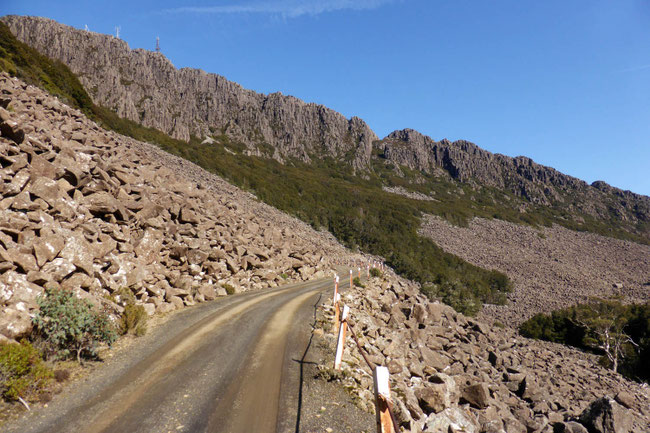
The road is a series tight hair-pin bends, like this:
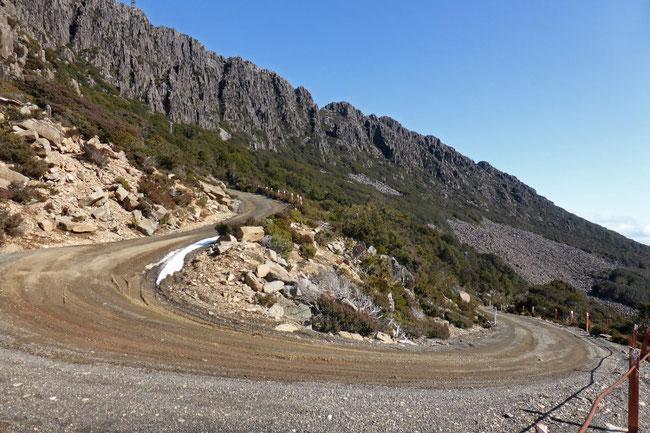
The road is similar to the road up Ben Lomond, Jacobs Ladder, but it's not as steep and tight. This is what the road looks like from the top of the mountain:
Traffic on the road
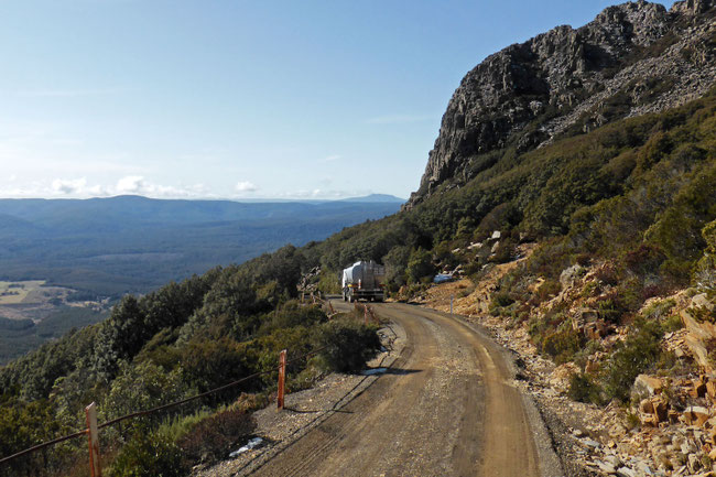
It's late winter now so I wasn’t expecting much traffic on the road. During my entire walk I only saw two vehicles – a fuel-delivery truck which came down as I was walking up, and a four-wheel drive vehicle driven by technicians who had been working on the equipment on the mountain, which came down as I was walking back down.
The lack of traffic on the road helped me to imagine it as a walking track!
Walking up Mount Barrow
My entire walk was 13 kilometres with a 700 metre total ascent. The climb up the road from the car park to the edge of Plateau was just under 4 kilometres, and the walk across the plateau to South Barrow was about 2.5 kilometres. Here's the Google Earth view of my walk:
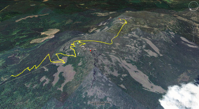
The grey areas on the side of the mountain are the scree fields – they are like rivers of boulders very slowly flowing down the slope.
The car park where I started this walk is here, on Google Maps. The drive to the car park from Launceston is 40 kilometres and takes about 40 minutes.
Driving up Mount Barrow
My original intention for this walk was to drive up onto the edge of the alpine plateau and explore from there.
As I couldn't be sure of the road conditions high up on the mountain, I changed my plans to trying to find somewhere on the side of the road to pull over on the way up, and walking from there. However, before I got to the mountain, I chanced upon a local person out for a walk, Ruth, who advised me not to try and park on the road, due to its narrowness; so I changed my plans again and parked in a carpark at the bottom of the mountain and walked the entire way.
While walking up the road I assessed the road conditions for driving up on a possible future winter walk, which would give me more time to explore the alpine plateau.
The road up the mountain is a single lane with occasional widened sections for passing. On the late-winter’s day that I walked up the road was generally in good condition, with just one section near the top having some moderately deep ruts that would require careful driving to negotiate.
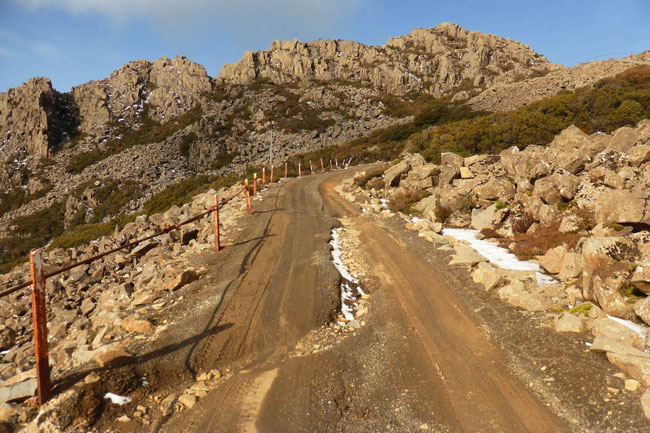
Some sections of the road were wet and slippery, and, as I showed before, some have remnants of snow on them.
I believe that most cars would have been able to drive up the road on the day that I was there, although you would have to take those wet and slippery sections very carefully. However, there is no way to know from the foot of the mountain how much snow there is on the upper levels of the road, and there are few places to turn around if you get stuck. So, I don't believe that’s it would be a good idea to drive up there in winter, unless you are in a four-wheel-drive vehicle, or have snow chains with you.
In summer, I expect that the road would be fairly easy to drive up if there had been no recent rain.
Parking on the road
While walking up the road I kept my eyes open for anywhere to park further up the road on a subsequent winter walk.
I found that, while there are a few spots where you could turn around, there's really almost nowhere to park once you leave the bottom car park, and are underway on the road.
There are some places where the road has been widened, where you may be tempted to park. You’d need to consider that there is a large amount of communications equipment on the mountain and at times, probably mostly in the summer, relatively large trucks, like the fuel-delivery truck that I saw on this walk, use the road to carry materials and equipment to the top of the mountain. For this reason parking on the side of the road, even where there seems to be room, would be an inconsiderate and risky idea.
There is one spot, here, on Google Maps, where you could perhaps just reasonably park; it looks like it may have been a small quarry or an area levelled for parking equipment while the road was being built.
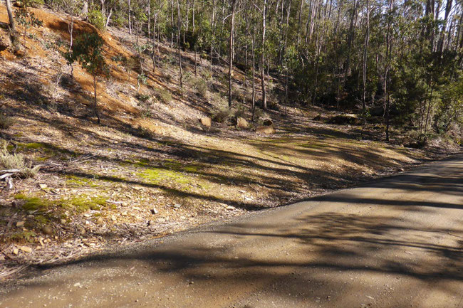
As you can see in the picture, it's fairly rough, and if you're not driving a high-clearance car you'd have to be careful about how you entered it.
Parking here would only save you about one kilometre of walking, and a hundred metres of ascent, compared to parking completely safely at the bottom car park.
Tags
If you enjoyed this blog post, you can find related posts under these headings:
Share this The Journey and the Destination post using your favourite social media:
Would you like to add something, or ask a question? Add a comment below (you can leave the 'Website' field blank):
Write a comment
Kam (Saturday, 08 December 2018 11:47)
Hi Chris,
If you had to recommend one walk out of Mount Barrow or Mount Arthur, which would you choose?
Chris (The Journey and the Destination) (Saturday, 08 December 2018 19:16)
Hi Kam,
I'd go for Mt Arthur, as it's more of a 'real' bushwalk. However, if you're not an experienced bushwalker, Mt Barrow may be better as it's impossible to go off the track and get lost, as the walk is on a road - the track on Mt Arthur is a bit vauge in some parts. Both have great views; Mt Arthur only from the top, and Mt Barrow all the way up.
Will (Saturday, 23 November 2019 06:28)
Hey there, great read!
How long did it take for you to walk from the bottom of the road to the plateau?
Chris (The Journey and the Destination) (Saturday, 23 November 2019)
Hi Will,
The walk from the car park at the bottom to the carpark at the edge of the plateau is about 3.5km. I expect that I would have taken about an hour and twenty minutes, with plenty of stopping to admire the view and take photos.
Thanks for letting me know that you enjoyed my post.
Steve (Wednesday, 14 February 2024 09:59)
Such a good description with no ego or bluster, just the
helpful and well reasoned information for all kinds of visitor.
You have a great manner
Chris (The Journey and the Destination) (Wednesday, 14 February 2024 11:59)
Hi Steve,
Thanks for your compliment!
Lou (Tuesday, 09 April 2024 03:11)
I found this information very useful and helpful as I'd been wondering about access and what the walk on the plateau is like. I have decided to walk up the road as well. Thank you very much.
Choose the Future (Tuesday, 09 April 2024)
Hi Lou,
I'm glad to hear that you found my post useful! Thanks for letting me know.
Walking up the road is great; however, If you did want to drive up this would be a better time than when I was there; I doubt you'd find any snow or mud this time of the year. A high-clearance car would still be a good idea, though.
Hope you have a good walk!